
Trace New Bedford Streets by Address
A street-by-street search begins with the exact situs, meaning the physical parcel address. Enter that address in the City of New Bedford property map, preserve the parcel ID and map/lot, and note whether an owner mailing address is shown separately. Next, use the recorded owner name in the Southern Bristol deed index. The purchase deed supplies a grantor, recording reference, and legal description that can carry the search beyond a changed street number. A voter record is a much narrower check: the state form verifies one person’s own status when the required information is known, rather than producing a street roster. Historical street sections then add dated address clues.
Each step has a different purpose. The map anchors geography. The deed chain identifies recorded transfers. A municipal voter-list request, when lawful and focused on public fields, can be a dated election record. A criss-cross directory is a historical snapshot. None alone establishes every person connected with a New Bedford address.
- Search the normalized number and street in AxisGIS, then save the situs address, parcel ID, map/lot, source date, and any visible owner or mailing information.
- Open the parcel card and use the map context to check the selected polygon, street suffix, direction, unit number, and nearby cross street.
- Search the recorded owner as a grantee in the Bristol South Registry, inspect the purchase deed, and capture its legal description and book/page or document number.
- If a voter-status question concerns one known individual, use the required full name, date of birth, and residential ZIP. For a municipal list, request only public fields, a date, and a defined format.
- Read the historical street section by number, then move to the alphabetic entry for occupation, household cues, or another dated address.
Note: A record should be labeled as parcel owner, recorded party, voter, or historical directory entry, rather than merged into one current-household claim.
New Bedford Street Directory Search Fields
New Bedford AxisGIS is the practical parcel starting point. The city quick guide documents type-ahead searches by owner name, street address, and parcel ID, plus a search/filter control that adds pushpins. Its layers and visual tools help distinguish the selected parcel from the rest of a block. The map is assessment and geographic evidence, not a substitute for the instrument recorded at the Registry.
| AxisGIS field or control | Street-directory use |
|---|---|
| Owner name | Type-ahead search for a recorded or assessed owner; preserve spelling variants for the deed search. |
| Street address | Type-ahead search for the situs address, with normalized number, suffix, direction, and unit checked. |
| Parcel ID | Type-ahead search for the exact parcel identifier shown by the city, without inventing a standard format. |
| Search/filter | Adds matching parcel pushpins to the map for a controlled street or address review. |
| Layers | Turns map layers on and off, including contextual zoning, infrastructure, census, open-space, and drainage layers. |
| Abutter’s List | Starts the city’s parcel-based abutter workflow; the published guide does not specify a radius rule. |
| Street View / Bird’s Eye View | Provides visual context for the parcel and street, not proof of ownership or who lives there. |
| CAI Property Card | Links to detailed property data; displayed fields can vary by the selected parcel and date. |
A parcel is the mapped unit of land used for assessment and GIS work. A situs address is the physical location of that parcel. A plat is a recorded plan or map used to describe land, while a criss-cross directory is the street section of a directory that moves from address to name. These keys often agree, but they are not interchangeable.
New Bedford Street Directory Map Layers
The city’s DPI Public Map REST service is a separate official GIS channel. It exposes city offices, polling locations, current DPI projects, city-boundary material, public-infrastructure projects, and a registration-vote table. The service supports Identify, Query, Find, and Export Map. Its stated maximum record count is 2,000, so a large street review must be narrowed and checked for truncation rather than treated as a complete list.
The official city GIS service directory is shown below.
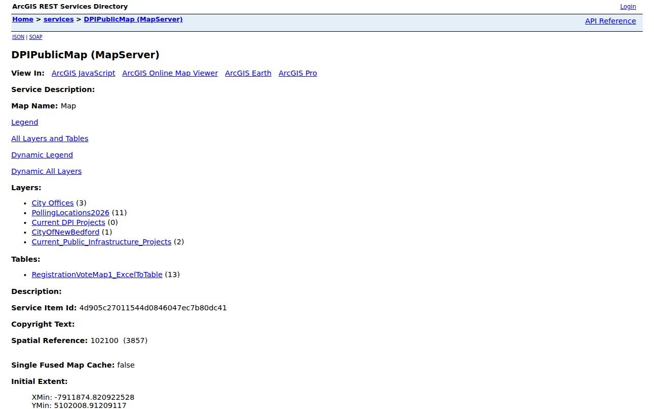
Use those services to confirm a parcel’s geometry or municipal context. The research did not confirm a public distance or buffer tool, so an adjacent-parcel review should rely on clicking mapped parcels or the formal Abutter’s List workflow instead of claiming a radius search.
New Bedford Street Directory Source Routes
Address-keyed sources work best as a chain. A parcel ID ties the city map to the assessment record, while an owner name and legal description connect the parcel to land records. Permit and planning files can date a project at the address. Local voter information and old street sections are dated, limited evidence, not a live list of every person at a location.
| Source | Route | Shows | Does not show |
|---|---|---|---|
| AxisGIS property map | Owner, address, or parcel-ID type-ahead; map/filter | Parcel, assessed owner, property, tax, sale, and layer context | Every person living at the address |
| Parcel and DPI GIS services | Map browse, Identify, Query, Find, or Export Map | Parcel shapes and city geographic layers | A complete named street list without a linked public attribute |
| Bristol South Registry | Owner, grantor/grantee variants, book/page, document, or plan | Recorded transfers, liens, plans, dates, and legal descriptions | Whether a recorded party lived on the parcel |
| City planning abutter file | Address, map/lot, board, and project route | Project contacts, owner/mailing clues, site plans, and dates | A continuing census of nearby people |
| DPI permit scans | Year, type, filename, address, or map/lot, then targeted request | Date-specific work, site, owner or representative, and plan clues | A complete online permit history |
| Voter records | Individual status form or a focused municipal-list request | Lawfully public registration fields and status context | People who are not registered or protected records |
| Directory street section | Street, number, cross street, and publication year | Historical address, occupation, and household clues | Current status or every past person at an address |
The city abutter application reinforces the distinction between a subject MAP #, LOT(S) #, and ADDRESS on one hand, and an owner NAME and MAILING ADDRESS on the other. Carry both the geographic key and the role of each named person into a street-directory note.
New Bedford Street Directory Deed Chain
The Bristol South Registry record search supplies the legal chain behind a parcel. Start with the current assessment owner, search that person as grantee, read the purchase deed, and extract the grantor and legal description. Search that earlier party as grantee for the preceding acquisition. Name variants matter, including prefixes such as De Mello or DeMello and La Cruz or Cruz. A legal description can bridge a street-number change because it may use a plan, lot, prior owner, or abutting parcel rather than the modern address.
The Registry governs a five-town Southern District: New Bedford, Acushnet, Dartmouth, Fairhaven, and Westport. Confirm the municipal boundary as well as the recording district before calling a result a New Bedford parcel. Recorded-land images are available online back to Book 605. The office, public counter, copy center, and current online account checkout are the routes when an image is needed or a web result is incomplete.
The Registry’s record-search instructions are pictured here.
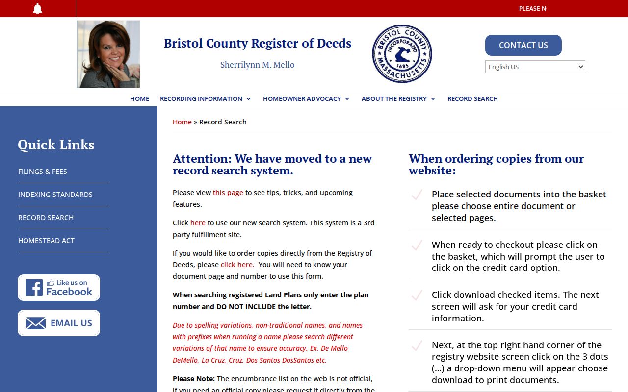
Do not rely on the Registry’s web encumbrance list as an official record. Its Certificate 13109 example omitted document 36720 because of back-indexing, which is why the grantor/grantee index and the instrument image remain necessary checks.
New Bedford Street Directory Old Indexes
Older land research moves to the Registry’s scanned grantor/grantee indexes, not to a guessed online date cutoff. The published ranges are 1690–1837, 1837–1885, 1886–1902, 1903–1917, 1918–1932, 1933–1957, and 1958–1972/77. These scans point to names and book references for the title trail. They are especially useful when a historical address becomes a larger lot, estate, plan, or earlier street label.
The official old-index collection is shown below.
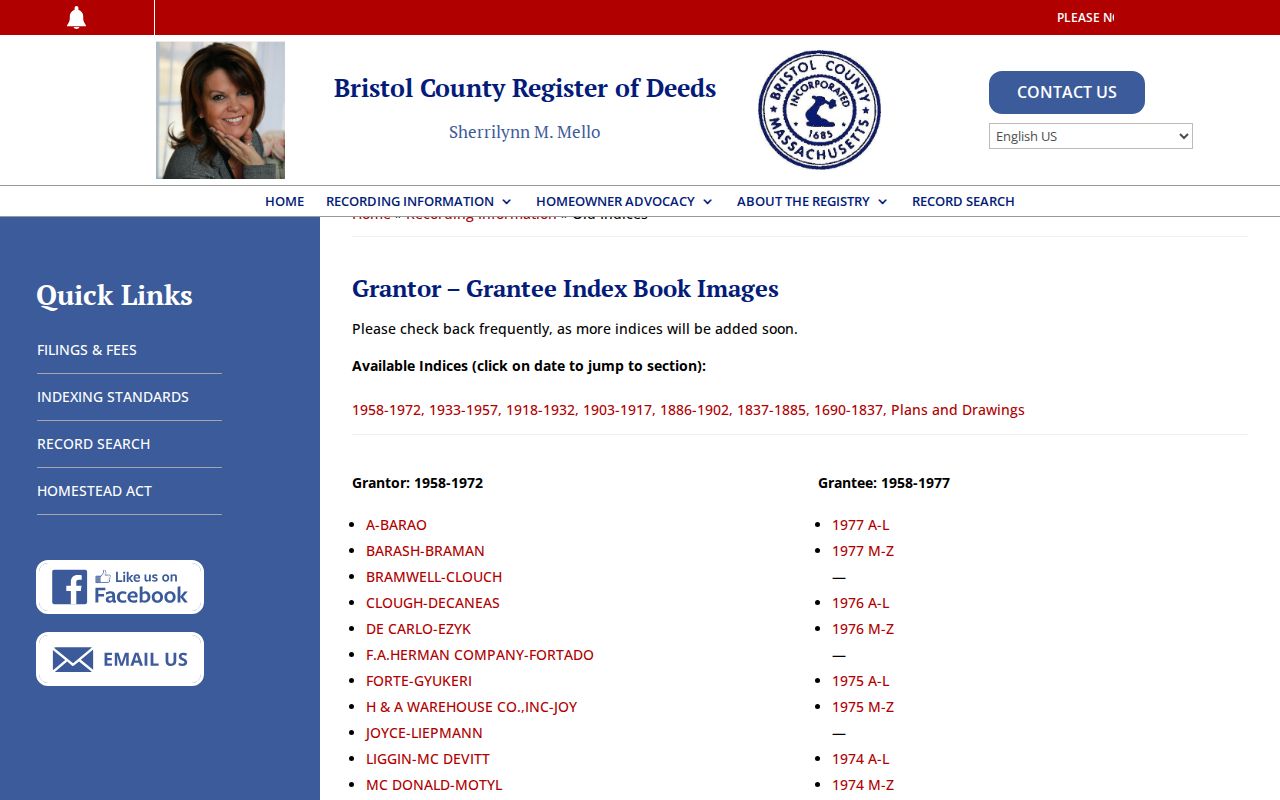
For older documents, use the counter or copy center when the scan points to an instrument that needs inspection. The Registry announced a 2025 online copy-account checkout process, but the counter remains an important fallback for index questions and copy handling.
New Bedford Street Directory Permit Clues
New Bedford DPI scanned permits add a date-specific municipal layer. Folders are organized by year and type, and filenames can contain a permit number, street, project, or assessor map/lot. That can place construction, an addition, driveway work, or planning review at an address. It does not prove that every permit is digitized or that every filename is searchable by owner.
When the scan folder does not answer the question, ask the responsible city custodian for a defined address, permit type, and date range. A public-record request under Massachusetts law may be electronic, mailed, in person, or verbal, though a written request is preferred. The agency can provide existing records but need not create a new street-wide compilation.
New Bedford Street Directory Voter Limits
The Massachusetts Voter Registration Search is an individual-status tool. It requires first name, last name, full date of birth, residential ZIP, and an agreement checkbox. A recent registration may take two or three weeks to appear. A no-match is not proof that a person does not live in New Bedford, and the form is not a street-by-street source.
A municipal voter-list request goes to New Bedford election officials and should name the list date, desired public fields, and requested format. Public election guidance identifies name, address, party, date of birth, active or inactive status, and voter ID among local-list fields, with additional limits and protected records. Phone and email fields are excluded. The statewide central registry is restricted by G.L. c.51, §47C, so it is not a public statewide roster.
Note: Keep voter status, parcel ownership, and historical address entries in separate columns because each has a different date and legal purpose.
New Bedford Street Directory Street Sections
Historical directories offer a reverse route when the goal is a prior address. Find the street and number in the street section, transcribe the listed name, then use the alphabetic portion for occupation, spouse or status notation, and another listed address. A directory volume is a snapshot near its publication date. It should be paired with a deed recording, census enumeration, obituary, permit, or plan before a longer connection is asserted.
The city-directory collections themselves are cataloged in the New Bedford Directory Book. For a street search, their most useful feature is the address section, not a claim that every name in a building or business listing was part of one household. Wharves, schools, churches, mills, and multi-unit sites can yield officers, trustees, agents, project representatives, or directory contacts instead.
New Bedford Street Directory Numbering Caveat
The 1852 New Bedford directory street guide gives a local historical clue: it describes bearings from City Hall and says that numbers commence at a cross street. That helps explain why a nineteenth-century address can need a cross street, street spelling, or nearby landmark before it can be tied to a current parcel.
No official citywide renumbering or renaming chronology was located. Treat an apparent number change as a working hypothesis until an old directory, deed, plan, assessor map, or Sanborn sheet provides the bridge. Preserve alternate numbers, old spellings, cross streets, lots, plans, and ZIP information in the research notes.
New Bedford Street Directory Access Routes
Online tools are only part of the local access chain. AxisGIS provides owner, address, and parcel type-ahead plus a property card. For older assessment material or a correction, use the Assessor’s public counter or make a focused record request. The Registry provides its search system, scanned old books, a public counter, a copy center, and online account checkout for copies. Its recorded-land web images begin at Book 605, while older index scans reach back to 1690.
City DPI permit scans are a first pass, followed by a targeted records request when the needed file is absent. A voter question is limited to the individual form or a municipal-list request for public fields. The library’s historical street sections supply another route when the address question reaches an earlier era. Access conditions, redaction, and date coverage differ, so note the custodian and retrieval date beside every result.
Limits of a New Bedford Street Directory
Public address records have protected edges. A parcel card can identify an assessed owner but may not identify everyone who lives there. Deeds prove a recorded transaction or interest, not residence. Utility customers, motor-vehicle addresses, protected voter records, Address Confidentiality Program addresses, children, and sealed or impounded court material are not part of a general street search. Do not use an old directory, deed, voter entry, or obituary to infer a person’s current location.